
Trek
Traverse of the Vercors Highlands
When you talk about the Vercors and the many wild adventures you can have there, conversations often turn to the Highlands.
Let's step into the scenery.
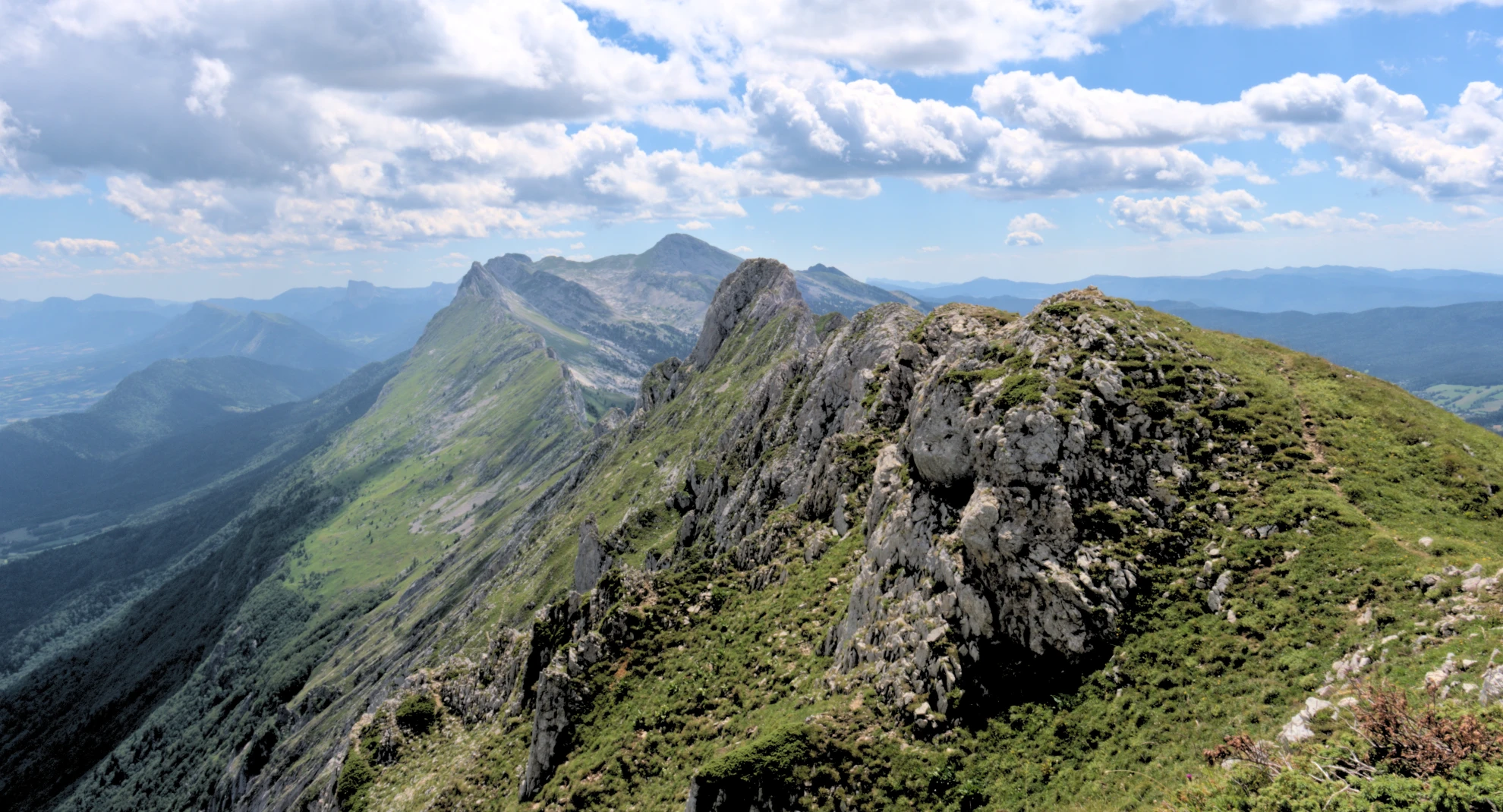
The Vercors Highlands: no roads, no villages. The scarcity of surface water has kept this area apart from any permanent human presence.
The Highlands Nature Reserve is set in the Vercors Park, in its highest and wildest section. With its 17,000 hectares, it's the largest land nature reserve in mainland France. Other protection measures have been added since. At its centre lies the most recent integral biological reserve, officially created in 2009. The Vercors Regional Park coordinates the various management plans for these protections.
Today, these measures protect natural riches few would expect and slow the development of human infrastructure. Who would have thought, when the nature reserve was created in 1985, that the wolf would return on its own to this area 12 years later?
Few signs, no proper refuge, but unguarded shelter cabins. These conditions may seem awkward, but they are the guarantee of immersion in a "real", preserved nature. A luxury in our "over-equipped" world.
The variety of landscapes in the Highlands offers a striking journey between mountain forests, green pastures, dry meadows, cliffs and sharp ridges, with all the richness of flora and wildlife that have settled there: orchids, edelweiss, ibex, marmots, vultures, red deer and wolves are perfectly at home.
The Highlands can be crossed on horseback, by mountain bike or on foot. As you'd guess, it's a journey through fantastic landscapes that may be punctuated by encounters with wild mountain fauna.
This multi-day hike requires trading the comfort of a bed for the pleasures of bivouacking in these Vercors landscapes.
As mountain leaders, what we offer below is a tour from north to south: short descriptions, fine photographs, moving freely from one season to another.
The Pied Vert mountain leaders run a 3 to 6 day trek from north to south, starting from Saint-Nizier-du-Moucherotte or Corrençon-en-Vercors, with alpine variants or easier ones, off the beaten paths. We adapt to your wishes and build tailored adventures, at your walking pace and to your comfort needs.
Tempted by the adventure?
Through this presentation, we wish you an inspiring digital journey that could turn into an adventure along the GR91 or as a guided trek in the Vercors, making cultural, sporty or photographic detours easier.
Traverse of the Highlands in 4 days
Minimum altitude: 540 m
Maximum altitude: 2340 m
Distance: about 58 km
Time: between 20 and 30 hours
1. Corrençon-en-Vercors
- Jasse du Play
Walking time: 6h - 7h
Elevation +: 637 m
Distance: 17.5 km
The Grande Moucherolle, second high point of the Vercors, stands above the golf course, which in every season offers a sought-after habitat for hares, large deer and their predators. Winter in Corrençon is the start of the nordic ski trails. From November to late April, we may meet snow on our way. Then snowshoes are needed.
The grass of the golf course soon gives way to lapiaz. Their geometries are always fascinating.
Soon we leave behind the Le Clariant inn. This hike from Corrençon really begins.
It was the last chance to taste a blueberry tart, but no matter.
The path moves through a forest mostly made up of spruces: a pessière.
Here already is the marker for the 45th parallel north. We're exactly between the North Pole and the Equator.
Finally, after the first five kilometres of walking, a sign reads Vercors Highlands Nature Reserve. A map describes the geography and the main prohibitions are listed for hikers: no picking, no fires, mountain bikes only on authorised sections.
Past this sign, a clearing opens, and in a small dip hides the charming Cabane de Carrette, open to all.
This cabin, like others along the route, offers hikers a roof, a table, a stove and enough space to lie down in your sleeping bag.


The Darbounouse pasture
Leaving the clearing, the path takes us back into the forest.
A detour from the GR can lead to the Grand Pot clearing. A more sporty start lets you arrive via the Tête des Chaudières via the Pas Ernadant.
Provided you have some mountain navigation skills, the 1:25,000 map opens up many alternatives to suit each person's wishes and physical abilities.
We're back on a forest path. It climbs gradually.
Crossing the Highlands by sticking to the marked GR avoids endless steep climbs. The technical challenge lies more in managing water once the last snowfields have vanished (from June onwards).
Here at last is Darbounouse. An immense stretch where sheep graze in summer. Crossing it to the south-east, we're at the door of the Highlands integral biological reserve.
The Canyon des Erges presents a fine little climb up to Tiolache du Haut. A viewpoint over the part least touched by people. We then continue into this increasingly wild setting up to the Jasse du Play cabin, which has one of the rare water sources of the area. We can finally drop our packs to bivouac in the fine surrounding pasture.


2. Jasse du Play - Pas des Bachassons
· Walking time: 6h
· Elevation +: 770 m
· Distance: 13.5 km
After a good breakfast, we head towards the Grand Veymont, the highest point of the Vercors. We drop down slightly to the Plaine de la Chau, and there the landscape opens further over these vast pastures in the south of the nature reserve.
At the crossroads of the Plaine de la Chau, cairns lead us towards the Pas de la Ville.
Shall we walk around the Grand Veymont or climb it as a traverse?
Going via the Pas des Bachassons for the incredible landscape of the Plaine de la Queyrie and its solitary tree is certainly worth the detour.
It's also where we can drink from one of the most reliable sources in the Highlands, and pitch our camp among the subalpine meadows full of marmots and ibex, with an imposing view of Mont Aiguille. Will we be lucky enough to hear the howl of wolves in the night?


3. Pas des Bachassons - Cabane de Châtillon
· Walking time: 6h
· Elevation +: 475 m
Distance: 15 km
After waking up in one of the finest spots of the Vercors, we head south again and cross the majestic Plaine de la Queyrie glimpsed the day before. It's a chance to explore an old Roman quarry where impressive remains of massive columns, cut on site, can still be found.
We then walk through a moon-like landscape to the Chaumailloux cabin, set in a green pasture that opens onto the vertiginous south face of Mont Aiguille.
From there we have several options: head to the imposing Archiane amphitheatre, descend through the wild Vallon de Combau, or carry on to the Glandasse.
Not quite ready to return to civilisation, we pick the latter. We turn south-west to cross some of the wildest stretches of the Vercors towards the Pié Ferré, summit of the Glandasse mountains, which look over Die. In the warm season, we'll likely find hundreds of edelweiss, the floral symbol of the Alps.
The griffon vultures are there, gliding effortlessly above the pastures. Will we be lucky enough to see one of the rare bearded vultures of the Vercors, the largest bird of prey in Europe?
We then drop down to the Cabane de Châtillon, where we'll put down our packs for the night, and maybe have a chance to chat with the shepherd, who's never short of striking mountain stories.


4. Cabane de Châtillon - Châtillon-en-Diois
· Walking time: 2h
· Elevation +: 0 m
· Elevation -: 1183 m
· Distance: 6 km
After watching the vultures take flight in the morning sun, we start the descent from the Highlands towards the valley, passing between the cliffs where the great raptors nest. Perhaps we'll see the small wallcreeper, a one-of-a-kind bird that feeds on insects found on rocky walls.
We follow a switchback path back to the conifers and then the shade of mixed forest. In autumn in the Vercors, arriving at this mountain level brings striking reds and oranges. In spring, it's the vivid green of beeches coming into leaf that catches the eye. But what's that sound in the pines? Could it be the song of cicadas? We're clearly in the south already.
Soon, on a breath of warm air, the smells of lavender fields reach us, and suddenly we arrive on the path leading to the fountain square of a beautiful little Provençal village, where we cool down in the shade of the great lime tree. We're in Châtillon-en-Diois, and this is where our traverse ends. Tired, but rich with a real journey from the vast resinous forests of the northern Vercors to the doorstep of Provence.


How long have we walked? Has the hike lasted a weekend, 3 days, a week? Hiking fully self-sufficient means balancing the weight of your pack to keep the pleasure intact. Preparing and carrying a week of food without being crushed by the pack takes serious planning.
Going solo means carefully planning your traverse in an area where hiking in the Vercors can get serious: low water availability, no phone coverage.
Going with a Pied Vert mountain leader means having a guide with deep knowledge of the territory, who will share their know-how so you can hike independently with a balance of comfort and adventure.
Tempted by the adventure?
The company of donkeys in the Vercors lightens shoulders, provided you choose an attentive pace and a suitable route for a traverse of the Vercors Highlands in 2026.
More information by phone on 07 66 64 90 96 or by email at contactpiedvert.com .
Discover also
Our nature activities in the Vercors:
- Hiking and ascent towards
The summits of the Vercors


You can also (re)discover: